


North_America_from_low_orbiting_satellite_Suomi_NPP
An image of the Earth taken from the VIIRS instrument aboard NASA’s Earth-observing research satellite, Suomi NPP. This composite image uses a number of swaths of the Earth’s surface taken on 4 January 2012.
E. Stephen Burnett on Jun 17, 2014 ·
Share a reply
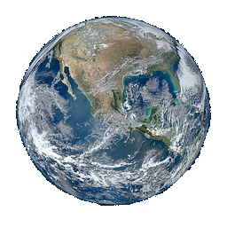
An image of the Earth taken from the VIIRS instrument aboard NASA’s Earth-observing research satellite, Suomi NPP. This composite image uses a number of swaths of the Earth’s surface taken on 4 January 2012.


Share your fantastical thoughts.